 |
| Most of the Knickerbocker Creek loop was like this (pc Facchino Photo) |
We then headed through a meadow and start a pretty good drop down to Highway 49. I got passed by 5-10 runners on the somewhat technical downhill (which was pretty much a creek in parts), which was a little disappointing. Downhill isn't necessarily my strong suit, but I was taking it more cautiously than others. I think the IT band issues I've had over the years have made me tentative and less willing to attack them, but I'm to the point now that my ITs are usually good until sometime after mile 50 so I shouldn't be such a wuss. I also just need to practice technical downhilling more than I have been. This two mile section drops about 800', and I ran it in 10:23 pace.
We crossed the highway where Western States legend Tim Twietmeyer and URP's Eric Schranz were cheering on the runners, and then dropped down on fire road to run above the roaring Middle Fork of the American River. The rain even let up for the first time, and it looked like it might turn into a nice day as I took off my rain shell and stowed it in my pack. The fire road rolls along here for about 6 miles with a couple of 150'-200' climbs mixed in. I passed a few, got passed by a few, and chatted up a few runners. This section was just another reminder that if I really want to cut my time on a course like this, I need to get faster on the runnable sections. If I can comfortably run along at 9:00 pace instead of 10:00-10:30 on the flats, that will make a big difference. With those little climbs mixed in, I ran a decent 11:19 pace through here.
 |
| Feet were wet from the start to the finish (pc Facchino Photo) |
I was looking forward to starting the climb out of the canyon, as that is my strong suit relative to most other mid-packers and I knew I'd start making up some ground. Sure enough, I started chewing people up. I even got three separate comments about how fast I was power hiking as I plowed past. This section starts with about an 800' climb over four miles, rolls along for a bit, and then ends at almost exactly 26.2 miles with Goat Hill, 1/4 mile with a 20% grade. I covered this 10 mile section in 2:09, a 12:53 pace.
Going into the race I had beating my PR of 5:54 as an A goal, and sub-6:00 as my B goal. But with the weather forecast and trail conditions I decided to just take the day as it came and see where things stood when I got to the top of Goat Hill. I didn't print out the pace chart, didn't even look at my watch for the first time until the end of the first loop, and rarely checked it throughout the day. I hit the aid station at the top of the climb in about 5:10, filled a bottle and drank some coke, and kept going. With five miles to go including the 450' climb from hwy 49 back to Cool still ahead, I knew it wasn't too likely that I could get in sub-6:00. But I remembered that the course had measured closer to 30 than 31 miles on my GPS in the past. "So you're telling me there's a chance!" I decided to just charge on and see what I could do.
After another quick climb it was a pretty steep technical descent, losing about 400' in a mile or so. I did my best to pick my way through the rocks, mud, and water as it started to rain again. I'm checking my watch as the traffic noises of Highway 49 start to pick up, but it always takes longer than you think it will to finally come out of the clearing and cross the road. This is the final aid station, and I knew it was over a mile to the finish - and my PR time was already gone, as was the chance at sub-6:00. So what, let's finish this thing! I skipped the aid station and kept charging, and began the final climb up to Cool. I passed another couple of runners on the 250' rocky climb, and then stomped through the mud in the meadow up top. As I approached the finish I could hear someone splashing behind me, and I kept running hard to try and stay in front. Around the corner, splashing through the mud while trying not to fall in front of the gathered spectators, and across the line in 6:06:08 chip time. That was the fastest I've run that segment in my five times here, so I was happy to finish so strong even with my pre-race goals out the window. This time the course measured the full 31 miles (it's shown exactly 30 miles twice before), which shows how far off gps can be during trail races.
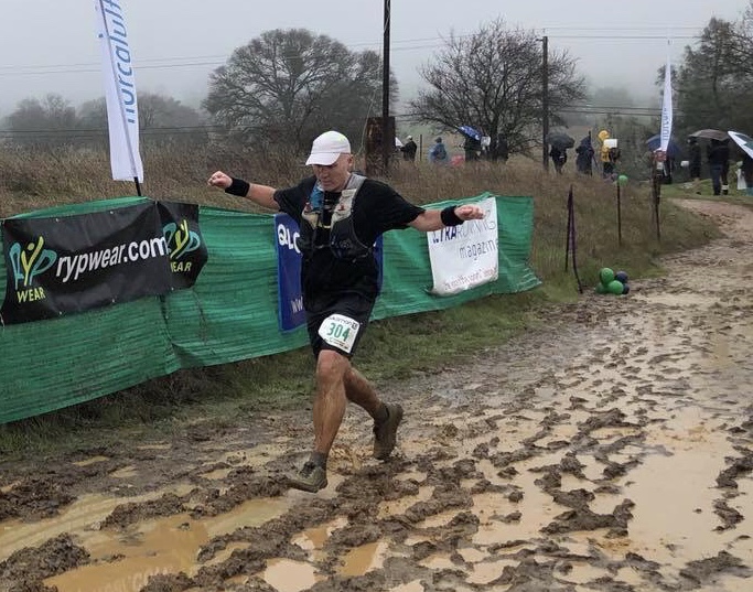 |
| Just trying to finish the last 100 yards without slipping (pc Keather Kehoe) |
No comments:
Post a Comment